
Garmin
Garmin GPSMAP 8410 10" Chartplotter with Worldwide Basemap
- SKU:
- 74722
- UPC:
- 753759213404
- MPN:
- 010-02091-00
- Condition:
- Brand New
- Availability:
- In Stock
- Shipping:
- Free 2-Day Shipping on Orders $500+
![Garmin Garmin GPSMAP 8410 10" Chartplotter w/Worldwide Basemap [010-02091-00] MyGreenOutdoors](https://cdn11.bigcommerce.com/s-ktouu2lc/images/stencil/1280x1280/products/45542/112678/Garmin-GPSMAP-8410-10-Chartplotter-wWorldwide-Basemap-010-02091-00_50883__35987.1715982760.jpg?c=2?imbypass=on "Garmin Garmin GPSMAP 8410 10\" Chartplotter w/Worldwide Basemap [010-02091-00] MyGreenOutdoors")
![Garmin Garmin GPSMAP 8410 10" Chartplotter w/Worldwide Basemap [010-02091-00] MyGreenOutdoors](https://cdn11.bigcommerce.com/s-ktouu2lc/images/stencil/1280x1280/products/45542/112675/Garmin-GPSMAP-8410-10-Chartplotter-wWorldwide-Basemap-010-02091-00_67548__44092.1715982748.jpg?c=2?imbypass=on "Garmin Garmin GPSMAP 8410 10\" Chartplotter w/Worldwide Basemap [010-02091-00] MyGreenOutdoors")
![Garmin Garmin GPSMAP 8410 10" Chartplotter w/Worldwide Basemap [010-02091-00] MyGreenOutdoors](https://cdn11.bigcommerce.com/s-ktouu2lc/images/stencil/1280x1280/products/45542/112676/Garmin-GPSMAP-8410-10-Chartplotter-wWorldwide-Basemap-010-02091-00_67549__06890.1715982752.jpg?c=2?imbypass=on "Garmin Garmin GPSMAP 8410 10\" Chartplotter w/Worldwide Basemap [010-02091-00] MyGreenOutdoors")
![Garmin Garmin GPSMAP 8410 10" Chartplotter w/Worldwide Basemap [010-02091-00] MyGreenOutdoors](https://cdn11.bigcommerce.com/s-ktouu2lc/images/stencil/1280x1280/products/45542/112677/Garmin-GPSMAP-8410-10-Chartplotter-wWorldwide-Basemap-010-02091-00_67550__12844.1715982756.jpg?c=2?imbypass=on "Garmin Garmin GPSMAP 8410 10\" Chartplotter w/Worldwide Basemap [010-02091-00] MyGreenOutdoors")
![Garmin Garmin GPSMAP 8410 10" Chartplotter w/Worldwide Basemap [010-02091-00] MyGreenOutdoors](https://cdn11.bigcommerce.com/s-ktouu2lc/images/stencil/100x100/products/45542/112678/Garmin-GPSMAP-8410-10-Chartplotter-wWorldwide-Basemap-010-02091-00_50883__35987.1715982760.jpg?c=2 "Garmin Garmin GPSMAP 8410 10\" Chartplotter w/Worldwide Basemap [010-02091-00] MyGreenOutdoors")
![Garmin Garmin GPSMAP 8410 10" Chartplotter w/Worldwide Basemap [010-02091-00] MyGreenOutdoors](https://cdn11.bigcommerce.com/s-ktouu2lc/images/stencil/100x100/products/45542/112675/Garmin-GPSMAP-8410-10-Chartplotter-wWorldwide-Basemap-010-02091-00_67548__44092.1715982748.jpg?c=2 "Garmin Garmin GPSMAP 8410 10\" Chartplotter w/Worldwide Basemap [010-02091-00] MyGreenOutdoors")
![Garmin Garmin GPSMAP 8410 10" Chartplotter w/Worldwide Basemap [010-02091-00] MyGreenOutdoors](https://cdn11.bigcommerce.com/s-ktouu2lc/images/stencil/100x100/products/45542/112676/Garmin-GPSMAP-8410-10-Chartplotter-wWorldwide-Basemap-010-02091-00_67549__06890.1715982752.jpg?c=2 "Garmin Garmin GPSMAP 8410 10\" Chartplotter w/Worldwide Basemap [010-02091-00] MyGreenOutdoors")
![Garmin Garmin GPSMAP 8410 10" Chartplotter w/Worldwide Basemap [010-02091-00] MyGreenOutdoors](https://cdn11.bigcommerce.com/s-ktouu2lc/images/stencil/100x100/products/45542/112677/Garmin-GPSMAP-8410-10-Chartplotter-wWorldwide-Basemap-010-02091-00_67550__12844.1715982756.jpg?c=2 "Garmin Garmin GPSMAP 8410 10\" Chartplotter w/Worldwide Basemap [010-02091-00] MyGreenOutdoors")
Description
Garmin GPSMAP 8400 Worldwide Basemap
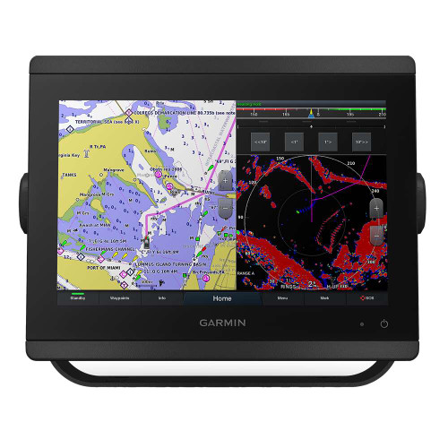
GPSMAP 8410 premium touchscreen chartplotter
The GPSMAP 8400 series gives premium Garmin touchscreen control to boats that need a worldwide basemap platform and a clean display for radar, cameras, autopilot, engine data, and networked accessories.

Where the 8410 fits
The 8410 is a 10-inch Garmin GPSMAP display for a premium connected helm. This section keeps the focus on the unit you are viewing: the display experience, the installed mapping, the sonar setup, and how it expands into a larger Garmin marine system.
Best fit
- Premium helm upgrade: a clean glass-style GPSMAP display for serious cruising, fishing, and system control.
- Worldwide Basemap: built for the 8400 worldwide basemap shopper who wants Garmin charting capability matched to this model.
System role
- Sonar setup: chartplotter-only operation with network sonar expansion available separately; choose the correct transducer or network sonar hardware for your boat.
- Garmin expansion: connect compatible radar, autopilot, engine data, cameras, Fusion audio, NMEA devices, and Garmin Marine Network equipment.
What's in the box
- Garmin GPSMAP 8410 touchscreen display
- Power cable
- NMEA 2000 drop cable
- NMEA 2000 T-connector
- Flush mount kit
- Sun cover
- Trim piece snap covers
- Documentation
Why this display
The GPSMAP 8410 is built for serious marine electronics systems where charts, radar, sonar, cameras, engine data, and autopilot may all share the helm. Premium Garmin touchscreen designed for a clean glass-helm installation with fast access to charts, network data, and connected accessories. Choose this model when you want a premium Garmin touchscreen that can anchor a larger networked setup.
Key features
- Premium touchscreen control: designed for a clean glass-helm style Garmin installation with simple flat or flush mounting options.
- Garmin charting: includes Worldwide Basemap for the mapping package shown on this listing.
- Network expansion: works as part of a compatible Garmin Marine Network with radar, sonar, cameras, autopilot, engine data, and additional displays.
- Sonar setup: Chartplotter-only display; add compatible network sonar separately.
Sonar and fishing expansion
- Chartplotter-first configuration: this non-xsv model is built for helms where sonar is handled through compatible network sonar equipment, another display, or a separate module.
- Live sonar capable system planning: compatible Garmin live sonar can be added through the right Garmin network hardware and transducer setup.
- Radar and camera ready: use the display as part of a broader Garmin network with compatible radar, cameras, sensors, and other helm devices.
Navigation, sailing, and helm control
- Preloaded mapping: Worldwide Basemap for global reference, with optional Garmin chart upgrades available for more detailed regional coverage.
- Optional Garmin Navionics Vision+: upgrade for premium chart features such as high-resolution relief shading, satellite imagery, sonar imagery, and more where available.
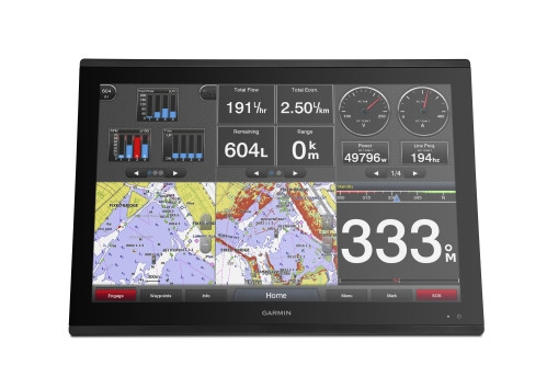
- Garmin SailAssist and sailing polars: view laylines, race start guidance, enhanced wind rose, wind data, tide/current/time slider, set and drift, wind speed, and polars for sail planning.
- ActiveCaptain app support: built-in Wi-Fi pairs with the mobile app for OneChart access, smart notifications, software updates, Helm features, Quickdraw Community data, and more.
- OneHelm and inReach integration: compatible third-party controls and paired inReach satellite communicators can be accessed from the chartplotter when properly equipped.
Connected helm control
- SmartMode station controls: create one-touch helm views for docking, cruising, fishing, cameras, radar, media, and other high-attention moments.
- GRID 20 remote ready: add the optional GRID 20 remote input device for intuitive remote control of a compatible Garmin marine system.
- Power-Pole shallow water anchor integration: when properly equipped with compatible Garmin and Power-Pole hardware, control smart anchor deployment, jog, auto stow, anchor drag detection, and end-of-route anchoring from the chartplotter.
- Force trolling motor integration: compatible Garmin Force trolling motors can be controlled from the display as part of a complete Garmin fishing setup.
- Engine and third-party integration: connect compatible engines, digital switching, weather, Fusion audio, media, VHF, AIS, and select OneHelm devices from one screen.
Before you buy
Confirm your screen size, mapping generation, sonar plan, mounting location, network cabling, and accessory compatibility before ordering. For help matching this display with radar, sonar, or networking accessories, contact MyGreenOutdoors before checkout.
Connections and expansion
Plan the installation around the display size, sonar configuration, radar and camera needs, chart storage, and the rest of the Garmin network. The connection highlights below help shoppers understand how this GPSMAP fits into a larger helm.
Spec highlights
Choosing the right Garmin GPSMAP 8400 Worldwide Basemap model
Use this section after reviewing the current product. It compares only similar GPSMAP 8400 Worldwide Basemap touchscreen displays, so shoppers are not pushed into unrelated Garmin pages too early.
GPSMAP 8410 (Current Display)
10-inch touchscreen · Worldwide Basemap · Base chartplotter + xsv sonar option
Best for compact premium helms where touchscreen control and Garmin Marine Network expansion matter where sonar is handled through a separate Garmin network module or display.

GPSMAP 8412xsv
12-inch touchscreen · Worldwide Basemap · Base chartplotter + xsv sonar option
Best for mid-size premium helms that need a clean Garmin touchscreen with room for charts, radar, and connected accessories with built-in xsv sonar flexibility.

GPSMAP 8416xsv
16-inch touchscreen · Worldwide Basemap · Base chartplotter + xsv sonar option
Best for larger offshore and cruising helms that benefit from split-screen charts, radar overlay, sonar views, and connected data with built-in xsv sonar flexibility.
GPSMAP 8424
24-inch touchscreen · Worldwide Basemap · Base chartplotter
Best for large glass-helm installations that need maximum screen room for charts, radar, engine data, cameras, and system control where sonar is handled through a separate Garmin network module or display.
Frequently asked questions
Does this model include a transducer?
No. This is a chartplotter-focused model, and sonar can be added separately through compatible Garmin network equipment.
What is the difference between 8400 and 8600 listings?
The 8400 pages are Worldwide Basemap models, while the 8600 GN+ pages include Garmin Navionics+ U.S./Canada mapping.
Should I choose the base model or xsv model?
Choose xsv if you want built-in sonar support on the display. Choose the base chartplotter if sonar is handled through another module, display, or network setup.
MPN: 010-02091-00 · UPC/GTIN: 753759213404

Related Products

Garmin
GMS 10 Network Port Expander

Garmin
Marine Network Cable, 40'

Garmin
Marine Network Cable, 20' - 16791

Garmin
RJ45 Marine Network Connector, 2 Pack - 17064

Garmin
Marine Network Cable, 6'
![Garmin Garmin NMEA 2000 Backbone/Drop Cable (1 Ft.) [010-11076-03] 010-11076-03 MyGreenOutdoors](https://cdn11.bigcommerce.com/s-ktouu2lc/images/stencil/590x590/products/3848/98969/Garmin-NMEA-2000-BackboneDrop-Cable-1-Ft-010-11076-03_4082__96066.1715927843.jpg?c=2 "Garmin Garmin NMEA 2000 Backbone/Drop Cable (1 Ft.) [010-11076-03] 010-11076-03 MyGreenOutdoors")
Garmin
Garmin NMEA 2000 Backbone/Drop Cable (1 Ft.) [010-11076-03]
![Garmin Garmin NMEA 2000 Backbone Cable (2M) [010-11076-00] 010-11076-00 MyGreenOutdoors](https://cdn11.bigcommerce.com/s-ktouu2lc/images/stencil/590x590/products/3849/98970/Garmin-NMEA-2000-Backbone-Cable-2M-010-11076-00_4083__13472.1715927846.jpg?c=2 "Garmin Garmin NMEA 2000 Backbone Cable (2M) [010-11076-00] 010-11076-00 MyGreenOutdoors")
Garmin
Garmin NMEA 2000 Backbone Cable (2M) [010-11076-00]
![Garmin Garmin NMEA 2000 Backbone Cable (6M) [010-11076-01] 010-11076-01 MyGreenOutdoors](https://cdn11.bigcommerce.com/s-ktouu2lc/images/stencil/590x590/products/3850/98971/Garmin-NMEA-2000-Backbone-Cable-6M-010-11076-01_4084__58000.1715927851.jpg?c=2 "Garmin Garmin NMEA 2000 Backbone Cable (6M) [010-11076-01] 010-11076-01 MyGreenOutdoors")
Garmin
Garmin NMEA 2000 Backbone Cable (6M) [010-11076-01]
![Garmin Garmin NMEA 2000 Backbone Cable (10M) [010-11076-02] 010-11076-02 MyGreenOutdoors](https://cdn11.bigcommerce.com/s-ktouu2lc/images/stencil/590x590/products/3851/98972/Garmin-NMEA-2000-Backbone-Cable-10M-010-11076-02_4085__48185.1715927854.jpg?c=2 "Garmin Garmin NMEA 2000 Backbone Cable (10M) [010-11076-02] 010-11076-02 MyGreenOutdoors")
Garmin
Garmin NMEA 2000 Backbone Cable (10M) [010-11076-02]
![Garmin Garmin NMEA 2000 T Connector [010-11078-00] 010-11078-00 MyGreenOutdoors](https://cdn11.bigcommerce.com/s-ktouu2lc/images/stencil/590x590/products/3852/98973/Garmin-NMEA-2000-T-Connector-010-11078-00_4086__11841.1715927858.jpg?c=2 "Garmin Garmin NMEA 2000 T Connector [010-11078-00] 010-11078-00 MyGreenOutdoors")
Garmin
Garmin NMEA 2000 T Connector [010-11078-00]
![Garmin Garmin NMEA 2000 Terminator, Male [010-11080-00] 010-11080-00 MyGreenOutdoors](https://cdn11.bigcommerce.com/s-ktouu2lc/images/stencil/590x590/products/3853/98974/Garmin-NMEA-2000-Terminator-Male-010-11080-00_4087__90683.1715927862.jpg?c=2 "Garmin Garmin NMEA 2000 Terminator, Male [010-11080-00] 010-11080-00 MyGreenOutdoors")
Garmin
Garmin NMEA 2000 Terminator, Male [010-11080-00]
![Garmin Garmin NMEA 2000 Terminator, Female [010-11081-00] 010-11081-00 MyGreenOutdoors](https://cdn11.bigcommerce.com/s-ktouu2lc/images/stencil/590x590/products/3854/98975/Garmin-NMEA-2000-Terminator-Female-010-11081-00_4088__23537.1715927866.jpg?c=2 "Garmin Garmin NMEA 2000 Terminator, Female [010-11081-00] 010-11081-00 MyGreenOutdoors")
Garmin